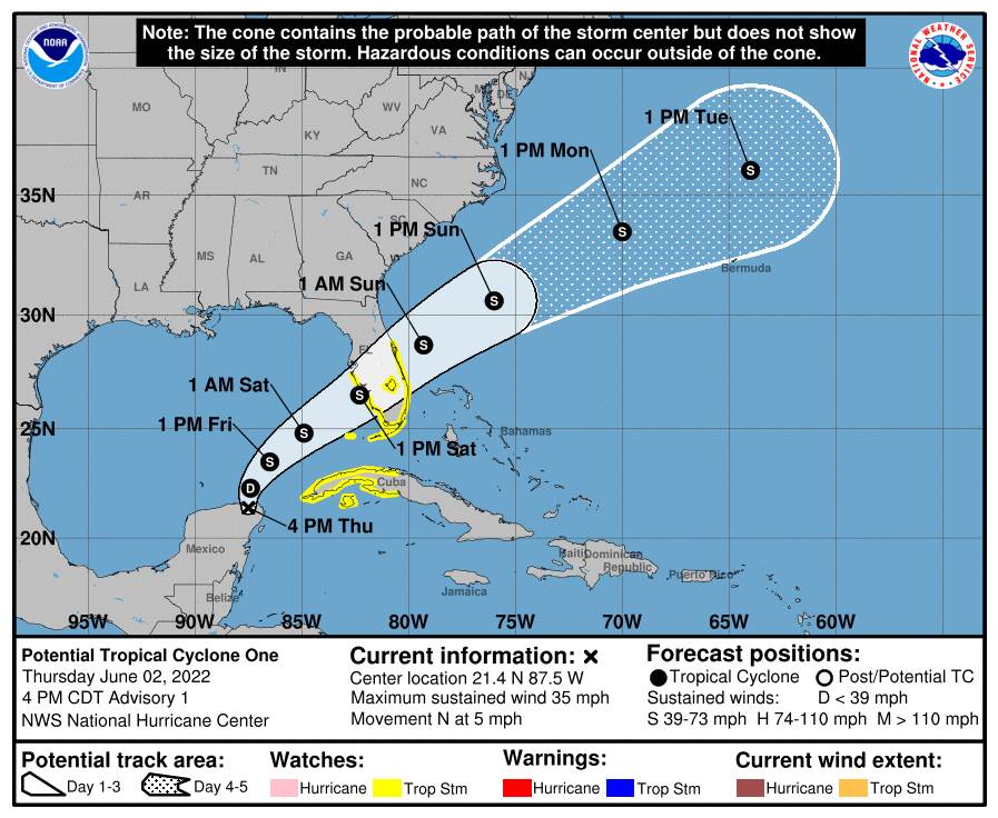
Potential Tropical Cyclone One.
First system of the season, should bring very heavy rain and little else to south and central Florida.
Potential Tropical Cyclone One.
First system of the season, should bring very heavy rain and little else to south and central Florida.
oh well tis the season.
hopefully it’s a relatively calm one like the past few years
The one main issue right now is the fact that the loop current is unusually active and situated up as far north as Tampa. If it stays that far north for the season, it could increase intensities of Gulf Storms.
So it definitely bears watching.
Other factors are not particularly noteworthy at the moment.
The system never closed prior to landfall and ironically that is making even MORE of a rain and flooding event for south and central Florida than it otherwise would have been.
Even though it is not technically a tropical system at this point, it does possess minimum Tropical Storm force winds.
The vast majority of the rain is occurring south of the center and the Miami area has flooded.
Many areas are expecting 12 inches of rain.
The system finally achieved a closed center of circulation, so we officially have Tropical Storm Alex with 50 mph winds.
The season has gone extremely quiet, a welcome change from recent years.
A couple of disturbances with fairly low organizational chances over the next five days in the Atlantic.
The Eastern Pacific and Central Pacific basins are both completely dead at this time.
If no system forms by September 1st, this would be the first August without an active system in a very, very long time.
I believe a very heavy and unusually late influx of Saharan dust predominantly responsible for the lack of activity.
There has been no official activity in the Atlantic basin since Tropical Storm Colin dissipated on July 3rd.
With slightly over 59 hours left in August, it will be close.
The area in red has about a 50% chance of forming in August.
The Saharan Dust Layer has abated and the tropics are finally firing up in earnest.
However, none of the four shown systems are expected to impact the United States.
Interestingly, both the Eastern Pacific and Central Pacific basins remain completely dead, with no systems, no invests, no nothing.
2 hours and 10 minutes left in August and no numbered Tropical Depressions and no named systems in the Atlantic Basin.
Looks like we will have the first August free of Tropical Systems in 25 years.
And only the fifth time under reasonable modern science in which there have been no tropical systems in the Atlantic Basin in August. The other years were 1929, 1941, 1961 and 1997.
And it is now official, no Atlantic Basin systems in August.
Does this mean anything, or is it just interesting?
It means nothing going forward.
It is more of an interesting demonstration of the effect of this year’s very massive Saharan Dust Layer that effectively and totally squelched tropical activity in the Atlantic Basin.
But it is dissipated now.
And it looks like the Atlantic is brewing up several systems as we speak, so this dormant season could become hot very fast.
The peak of the season, September 10th, is coming right up.
Thanks!
After nothing in August, Danielle formed early on the first.
Looks like we will have our first Hurricane of the season later today, though it will affect not a soul.
September 10th is typically the peak of the Atlantic Hurricane Season, but at the moment, we have only Earl about to make the transition to extratropical status. Several invests have been tracked but all have fizzled out in the Atlantic.
The culprit appears to be the fact that the Bermuda High is smaller and located farther north than typical, allowing the jet stream to pump dry air into the Atlantic.
Sahara dust was the squelcher during the summer.
The Bermuda High is the squelcher now, at least for the time being.
Probably should say that the “lack” of a Bermuda High is the squelcher.
Today’s surface map.
The only decent high is near the Azores in the far east Atlantic. The “Bermuda High” is located in two centers near New York City and Newfoundland.
After Earl passes, it will be interesting to see if the Bermuda High can get itself back together again and move to its more typical location.
Some aspects of the climatological system are not well understood, such as what is going on now, so it should be a good data year for scientists.
Does this mean the climate change crisis is over?
At least a little less scary?
No news is good news.
Actually, it means nothing, until we figure out what is driving these changes. It may be anthromorphic to a degree, though I suspect some non-anthromorphic changes are involved as well, but it will take time for the climate science to catch.
Here are the current models on recently formed Tropical Depression 7.
Here is the current Atlantic weather map.
The Bermuda High is well east of where it would normally be in September and very weak. Not a strong or well developed high at all. And previous cold front, now a stationary front, displaced it and will likely keep it well to the east for several days.
Which makes the long range modelling on TD-7 very dicey. Normally, these Atlantic systems are pulled up into the open Atlantic by the effects of the Bermuda high. But a weak and displaced Bermuda High, combined with a developing low pressure center off Florida, could pull this system towards the mainland. Hard to say as this is NOT a typical weather pattern. I will follow this system and see how it works out over the next week. Should be interesting.


